
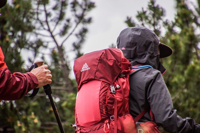
If you’ve ever thought about exploring Dublin beyond its pubs, shopping streets, and city charm, let me tell you something, hiking here is an entirely different experience. From my own personal experience, there’s something peaceful and grounding about walking through Dublin’s trails. You’re surrounded by green fields, coastal cliffs, forest paths, and the occasional sheep crossing your way. Whether you’re a beginner or someone who hikes every weekend, Dublin has trails that truly impress.
This guide is your detailed, no-fluff walk-through of the best hiking routes in and around Dublin, with an emphasis on maps, accessibility, terrain, and what to expect on each route. You’ll find the paths that suit your mood, whether you want sea views, forest trails, or mountain climbs.
Why Hiking in Dublin Is Special
Dublin has a mix of coastal and mountain trails within easy reach from the city center. What makes it unique is how accessible everything is. You can take a short train or bus ride and find yourself in nature in under an hour. The city’s location near the Wicklow Mountains and Dublin Bay gives you a rare combination, sea on one side, rolling hills on the other.
You don’t need to be an expert hiker here. Most routes are well-marked, and many are connected to public transport. Plus, the Irish weather, yes, even the drizzle, adds something magical. It’s not about perfection; it’s about the quiet moments you get while walking through history, nature, and stunning views.
How to Use Hiking Route Maps Around Dublin
Before you start, make sure you have the right tools. Most Dublin trails are available on digital map apps like AllTrails, Komoot, or OSi Maps. For offline adventures, the Ordnance Survey Ireland (OSi) maps are gold. These show detailed terrain, elevation, and official walking routes.
When planning your hike, check:
- The route distance and estimated time.
- Elevation gain if you’re after a challenge.
- Nearby parking or transport options.
- Trail markers, many Dublin trails use color-coded signs.
Bring a physical map if you’re going into the hills, since phone coverage can fade in remote spots.

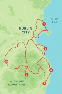
Top Hiking Routes in Dublin
Let’s go through Dublin’s best hiking routes, some easy, some tough, all unforgettable.
1. Howth Cliff Walk
The Howth Cliff Walk is one of Dublin’s most popular and scenic routes. Starting from the seaside village of Howth, this hike offers breathtaking views of the Irish Sea, Baily Lighthouse, and Ireland’s Eye island.
There are multiple loops to choose from, ranging from short 2-hour walks to full-day circuits. The main trail, known as the Howth Summit Loop, follows a coastal path that’s well-marked with purple arrows.
Map Tip: You can grab the official route map from the Fingal County Council site or use AllTrails for a GPS version.
Why You’ll Love It:
The fresh sea breeze, rugged cliffs, and small cafés at the end make it worth every step. From my own personal experience, catching the sunset from Howth Summit feels unreal.
2. Ticknock Forest Trail
Located just outside Dublin, in the foothills of the Dublin Mountains, Ticknock is ideal if you want both forest and city views. The trail winds through dense woods and open mountain slopes. On clear days, you can see the entire city and Dublin Bay spread below you.
There are several marked routes, Fairy Castle Loop being the most famous. It’s around 6 kilometers and leads up to an ancient cairn believed to be over 4,000 years old.
Map Tip: Use the Dublin Mountains Way map or the Coillte forest map, which shows all the forest paths and mountain bike trails.
Why You’ll Love It:
It’s close to the city yet feels miles away. The forest paths are calming, and the higher you go, the better the view gets.
3. Bray to Greystones Cliff Walk
Technically starting just outside Dublin, this coastal trail is a must-do. The 7-kilometer walk connects the seaside towns of Bray and Greystones. It’s a moderate trail, mostly flat, hugging the cliffs with waves crashing below.
You can start from either end, and both towns are accessible by DART train.
Map Tip: Look for the Bray Head Coastal Trail Map. It clearly outlines the cliff route, with emergency points marked.
Why You’ll Love It:
It’s easy to follow, filled with sea air, and ends with cafés and ice cream in Greystones. From my own personal experience, it’s perfect for clearing your head on a Sunday morning.
4. Hellfire Club Loop (Montpelier Hill)
If you like history with your hike, this one’s for you. The Hellfire Club trail leads up to the ruins of an 18th-century hunting lodge that locals claim is haunted. The hike is about 5 kilometers long, with a steady climb through forest trails leading to the top of Montpelier Hill.
Once there, you’ll get one of the best panoramic views of Dublin City.
Map Tip: Available on the Dublin Mountains Partnership map, which covers Montpelier Hill, Massey’s Wood, and nearby routes.
Why You’ll Love It:
The mystery adds fun, and the view from the top is unbeatable, especially at sunrise or sunset.
5. Dublin Mountains Way
This is the ultimate long-distance trail for serious hikers. The Dublin Mountains Way stretches over 40 kilometers, from Shankill in the east to Tallaght in the west. It passes through forests, open moors, and historic landmarks.
The route is fully waymarked with yellow arrows, and you can hike it in sections or tackle it in one go over a couple of days.
Map Tip: Get the official Dublin Mountains Way Trail Map by the Dublin Mountains Partnership—it’s detailed and reliable.
Why You’ll Love It:
You’ll see Dublin from every angle, from sea level to mountain ridge. It’s challenging, peaceful, and incredibly rewarding.
6. Tibradden Wood (Pine Forest Trail)
Just off the road to Glencullen, Tibradden Wood is an ideal spot for a short forest walk. The trail climbs gradually through tall pine trees before reaching a viewing point overlooking the city. There’s also a Bronze Age cairn at the summit, linking you to Ireland’s ancient past.
Map Tip: Use the Coillte Tibradden Trail map, available on their website.
Why You’ll Love It:
The quiet of the forest is refreshing, and it’s great for families or light hikers.
7. Killiney Hill Park Loop
If you want sea views without a long hike, Killiney Hill is your go-to. The loop is about 2 kilometers long and easy for any fitness level. From the top, you can see Killiney Bay, Dalkey Island, and on clear days, even the Wicklow Mountains.
Map Tip: Download the Dún Laoghaire-Rathdown County Council trail map for walking paths.
Why You’ll Love It:
It’s short, scenic, and close to the city. You can pair it with a beach stroll or a stop at Dalkey Village for coffee.
8. Massey’s Wood Heritage Trail
Located near the Hellfire Club, Massey’s Wood offers forest paths rich in history. It’s known for ancient trees, stone walls, and remains of old estate buildings. The route loops through a peaceful woodland with interpretive signs explaining the area’s background.
Map Tip: The Massey’s Wood Trail Map is available through the Dublin Mountains Partnership website.
Why You’ll Love It:
It’s quiet, shaded, and full of old charm, a hidden gem near the city.
9. Three Rock Mountain Loop
This is one of the more adventurous trails near Dublin. The hike takes you up to Three Rock Mountain, famous for its granite outcrops and panoramic views. It’s often linked with Ticknock or Fairy Castle routes for a longer adventure.
Map Tip: Combine the Ticknock Forest and Three Rock Trail maps for full coverage.
Why You’ll Love It:
The views stretch across the city and out to the Irish Sea. It’s a favorite for sunset hikes.
10. Carrickgollogan Forest Walk
This lesser-known trail offers stunning views of Dublin and Bray Head. The forest paths are peaceful, and there’s a short climb to an old chimney stack, a remnant of Dublin’s mining past.
Map Tip: Coillte’s Carrickgollogan Trail Map highlights the loop and viewing point.
Why You’ll Love It:
It’s quiet, short, and scenic. Ideal if you want a relaxing walk with a bit of history mixed in.
Seasonal Hiking Tips for Dublin
Dublin’s weather can shift fast, so be prepared. Here’s how to plan better:
Spring: Trails are green and full of blossoms. Bring waterproof shoes; the ground can still be wet.
Summer: Perfect for coastal hikes like Howth or Bray. Always pack sunscreen—it can surprise you.
Autumn: The forests of Tibradden and Massey’s turn golden. The air is crisp, ideal for photography.
Winter: Go for shorter hikes with clear paths, like Killiney Hill. Check conditions before heading into mountains.
Safety Tips While Using Route Maps
- Download maps offline before heading out.
- Tell someone your route if hiking solo.
- Stick to marked trails—some areas are private land.
- Bring layers; Dublin weather can flip from sun to drizzle in minutes.
- Always have water, snacks, and a backup power bank for your phone.
Combining Routes for Multi-Day Hikes
If you’re up for something longer, try linking some of these routes. For example:
- Dublin Mountains Way + Ticknock + Tibradden forms a scenic mountain corridor.
- Howth Cliff Walk + Killiney Hill gives you the best coastal contrast.
- Hellfire + Massey’s Wood makes a great forest-and-history combo.
You can easily plan these combinations using online hiking maps or apps.
Food and Rest Stops Near Major Trails
Half the fun of hiking around Dublin is grabbing food afterward. Here are some quick recommendations:
- Howth: The Brass Monkey or Beshoff’s for fish and chips.
- Greystones: The Happy Pear for a healthy post-hike meal.
- Ticknock: Marley Park café nearby for coffee and pastries.
- Dalkey/Killiney: Finnegan’s or The Queens Bar for a cozy pub meal.
Why You Should Explore Dublin’s Trails
Based on my overall experience, hiking around Dublin is about more than just exercise. It’s about reconnecting—with nature, with the city’s quieter side, and sometimes with yourself. Every trail has its story. The cliffs tell of fishermen and sailors, the forests hide ancient stones, and the hills whisper old Irish legends.
With the right maps and a curious spirit, you’ll find each route feels like discovering a piece of Dublin most visitors never see.
Final Thoughts
Whether you’re looking for an easy loop like Killiney Hill or a full trek like the Dublin Mountains Way, you’ll find every kind of trail around Dublin. Use reliable route maps, plan for the weather, and let each step show you something new.
From my own personal experience, the best hikes aren’t always the longest or hardest, they’re the ones that make you pause, breathe, and really look around. Dublin gives you that in every direction.
So lace up your boots, grab your map, and start exploring. The Dublin hills and cliffs are waiting.


